5 great hikes in Manitoba
 Image by PNW Production from Pexels. CC0
Come and visit the provincial parks of Manitoba! There are many parks to choose from, and many trails to hike. Here are five amazing trails to get you started:
-
Lakeview Trail
(Paved 3 km and 7 km), Birds Hill Provincial Park
This is the closest provincial park to Winnipeg. It is 30 kilometers from downtown Winnipeg (heading North-East), and 17 km from the Perimeter Highway. Incidentally, did you know that Birds Hill Park was developed in 1967 to celebrate Canada’s 100th birthday?This historic park has many different natural environments for you to explore – prairie, bog, and forest. It spreads out over 35 square kilometers.
Lakeview Trail is paved, and is great for wheelchairs, strollers, and rollerblades. The trail goes around the lake which you can also swim in. There are picnic tables, and a beach as well.
-
Cedar Bog
(Unpaved, 3.5 km/1.5 hours), Birds Hill Provincial Park
This trail goes through two natural environments: a cedar bog and a boreal forest. There is a bench and a bird feeder on the trail, so you can sit and enjoy the birds that come to eat! Although this trail isn’t paved, it’s easy to walk on. It may be wet in spring, so wear waterproof shoes. -
Pine Point Rapids
(Unpaved, 5.1 km and 7.9 km), Whiteshell Provincial Park
Pine Point Rapids is one of the best trails in Whiteshell Park. The park is a one hour forty five minute drive (139 km) from Winnipeg (heading East), and is beloved by Manitobans. On this trail you will experience the forest, a river, and large rocks. I recommend doing the full trail – the views are worth it!If you like animals, then this is a good choice for you. There are ducks and, rarely, otters in the Whiteshell River, and birds in the forest.

Pine Point Rapids, Robert Linsdell from Flickr. CC-BY
Here is a video of the whole trail:
, William’s Outdoor Adventures in Manitoba. -
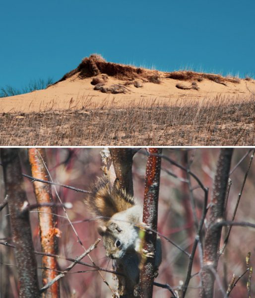
Spirit Sands
(Unpaved, 3.6 km), Spruce Woods Provincial Park
Spruce Woods is where you can see “the desert” in Manitoba. Actually, the Spirit Sands get enough rain each year (300-500 mm) for plants to grow on the sand dunes. The park is a two hour drive (180 km) from Winnipeg (heading South-West), but this exciting hike is worth the drive! You can also see the Devil’s Punch Bowl: a small lake that glows bright green.For this hike especially, bring water and watch the temperature – it’s hot in the desert! If you want to spend the night, there is a campground near to the Spirit Sands, but in a forest. There is a variety of campsites: those with power and those without power, and big and small sites.
-
Lighthouse Trail
(Unpaved 1.5 km), Hecla Provincial Park
Hecla Provincial Park protects both land around and the waters of Lake Winnipeg. This area is home to a large number of pelicans. The park is a two-hour drive (183 km) from Winnipeg (heading North).For thousands of years the Anishinaabe held ceremonies and gathered resources (berries and animals) on Black Island (one of the islands on the shores of Lake Winnipeg), and they still do so today. In 1876, settlers came from Iceland looking to make “New Iceland”. In fact, Hecla Island was named after one of the most famous landmarks in Iceland, Mount Hekla, a volcano. After fishing became less profitable, a park was developed to bring money into the area.
The Lighthouse Trail is a Manitoba classic! There is a campground, and a resort if you want to stay overnight. There are also two beaches for swimming, and good fishing too (pickerel, perch, pike, and silver bass).
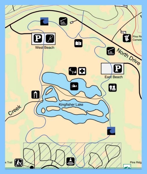
Birds Hill Provincial Park map. Contains information from the Government of Manitoba, licensed under the OpenMB Information and Data Use License (Manitoba.ca/OpenMB)

Birds Hill Provincial Park map. Contains information from the Government of Manitoba, licensed under the OpenMB Information and Data Use License (Manitoba.ca/OpenMB)
Photos taken by Brett Halajko. Permission to use granted by creator.

Spirit Sands Trail map. Contains information from the Government of Manitoba, licensed under the OpenMB Information and Data Use License (Manitoba.ca/OpenMB)

Hecla Island Lighthouse. Photo by Jasonbook99 from Wikimedia Commons. CC-BY-SA.
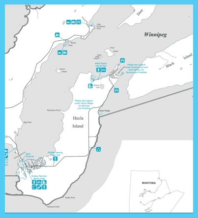
Hecla Provincial Park Map. Contains information from the Government of Manitoba, licensed under the OpenMB Information and Data Use License (Manitoba.ca/OpenMB)
Remember check the weather conditions before setting out to hike. Also remember to bring a lot of water and wear a hat.
Have fun hiking!
By Nastashya Wall
Community Resources
Here’s your copy of the Manitoba Parks Visitor Guide. It features our province’s 90 wonderful parks where you can swim, canoe, ski, fish, hike and camp. Get to know park regulations, as well as tips, to make your visit more fun and enjoyable.